
Thursday's 89 degrees broke a Bowling Green record from 1897. Now a cold front brings lows near 36 and patchy frost Sunday and Monday mornings.
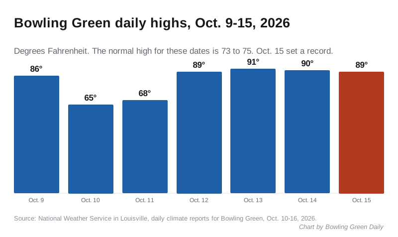
Bowling Green hit 89 degrees Thursday, the hottest Oct. 15 in the city’s weather records. By Sunday morning, forecasters expect frost.
The old record for the date was 87 degrees. It was set in 1897 and tied in 1920 and 1924. The National Weather Service in Louisville’s climate report for Oct. 15 marks the 89 as a record. Records for Bowling Green go back to 1870.
The high came at 1:05 p.m. The normal high for Oct. 15 is 73, so Thursday ran 16 degrees above it. The overnight low was 72 degrees, against a normal of 48.
A week of summer in October
Thursday capped a hot run. The weather service’s daily reports show highs of 89 or more four days in a row:
| Date | High | Record for the date |
|---|---|---|
| Monday, Oct. 12 | 89 | 94 (1930) |
| Tuesday, Oct. 13 | 91 | 92 (1928) |
| Wednesday, Oct. 14 | 90 | 94 (1928) |
| Thursday, Oct. 15 | 89 | 89, new record (old: 87 in 1897, 1920 and 1924) |
Tuesday’s 91 came within one degree of the 1928 record. The normal high on each of those days is 73 or 74.
The heat shows up in air conditioning demand too. The weather service counts cooling degree days, a measure of how much cooling buildings need. Through Friday afternoon, October had 75 of them in Bowling Green, more than double the normal 36.
Wednesday also brought thunderstorms and 0.87 inch of rain. That pushed October’s total to 2.03 inches by Friday, slightly above normal. The year is still dry: 35.29 inches since Jan. 1, about 5 inches below normal.
Then the cold
A cold front came through Friday. The temperature peaked at 75 just after midnight, and gusts reached 29 mph from the northwest, the Friday afternoon climate report shows.
The weather service forecast for Bowling Green, issued Friday afternoon, calls for:
- Friday night: a low around 43
- Saturday: mostly sunny, high near 60, north wind 8 to 14 mph
- Saturday night: clear, low around 36
- Sunday: areas of frost between 7 and 8 a.m., then sunny with a high near 66
- Sunday night: low around 36, patchy frost after 5 a.m.
- Monday: patchy frost before 7 a.m., high near 69
- Tuesday: sunny, high near 72
No frost advisory was in effect for Warren County as of Friday afternoon.
What it means for you
- Cover or bring in tender plants Saturday evening. Frost is most likely early Sunday and early Monday.
- Dress for 60 degrees on Saturday. That is nearly 30 degrees cooler than Thursday. The Downtown BGKY Harvest Festival runs 11 a.m. to 5 p.m. Saturday under a mostly sunny sky.
- Expect cold car windshields before 8 a.m. Sunday and Monday.
- The weekend guide has more on what is happening around town.
Have your say